The word ‘ham’ is of Old English origin and meant ‘village’. The founder may have been something like Blouwa. Whoever he was nothing is known of him.
There have been at least twenty variations on the name of the village over the centuries, including Blonwenham, Bluneham and Blouham. It is unlikely that Blunham was ever of any importance, but it was not out of the way. It stood, as it stands today, near the main route to London and a main river route to the wash.
Tempsford, a few miles away, was a place of some military importance at the time of the Danish invasion. The Anglo-Saxon Chronicle tells us that, in 921AD, the Danes built a fort there which the English captured later in the summer, and in the invasion of 1009AD, the Danes are recorded as having reached as far as Tempsford. It seems likely that Blunham shared in the danger and excitement.
Blunham next appears to our view in the Domesday Book, compiled in 1086 to give King William I a list of the current land holders and their Anglo-Saxon predecessors whom the Normans had ousted. In King Edwards’ time the land had been divided between eight freemen and a man of King Edwards’. William I granted a part of the manor to the Abbot of St Edmunds monastery in Suffolk. It amounted to 5 hides (600 acres). There was land for ploughing, meadows for oxen, and a mill. After Domesday, Blunham remains out of sight for a period.
From the Publication: ‘The Parish Church of St Edmunds’
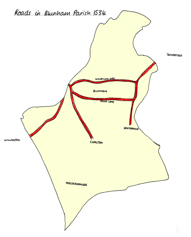
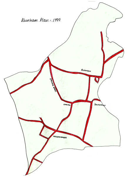
1534 – Perhaps the first thing to consider is how the village looked, which was much like the village looked up to the enclosure of 1799. Blunham used to be made up of two townships – Blunham itself, with all the houses concentrated in the village centre, and then to the South was Moggerhanger Township, composed of the hamlets of South Mills, and Chalton and Moggerhanger. The one church served the whole Parish.
Fields, as we know them, were found in Blunham Township only in the centre area behind and near the houses.
A road run in its present line from Barford Bridge to Willington: another ran from the bridge South East to Chalton. Between the bridge and the village centre the road was much in its present line, and entered the village by Shop Lane and so on and through and out to Tempsford. The road to South Mills continued straight past the Rectory, close to the river, and was only diverted at the time of Enclosure to increase the privacy of the grounds of the present Rectory gardens; and down the little side road to the river, and also a little way down the old road to South Mills, where now there are the riverside meadows.
There is evidence of a track or road from North End across towards Barford Bridge. The rest of the lad lay in the common fields, common meadow, arable or pasture.
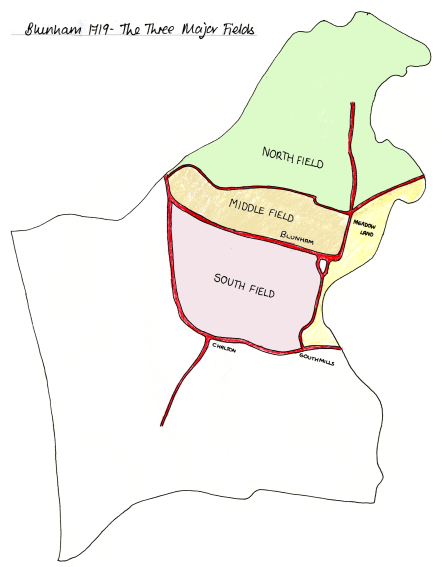
There was three great arable fields. South of the Barford Road was the Upper or South Field. Between the Barford Road and Northbrook the Middle Field and, finally, above Northbrook the North or Ham Field. Each field was composed of furlongs, which were blocks of unfenced arable strips, with names like Mare furlong, Gaul furlong, Mangthorne furlong, Camb furlong, Little Kickmead, Langland, and Simmons Cross Hedge furlong.
The meadows lay alongside the river: between the Willington Road and the river was Clive Hill Mead, downstream from Barford Bridge was the Barford Bridge Pasture, then West Mead, then up towards Tempsford sluices, East Meadow and coming South again against the Ivel: Barkas Meadow.
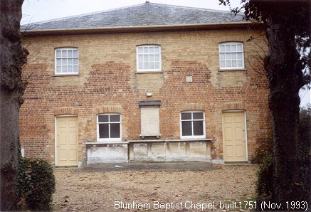
The common pastures where Blunham people put their sheep and geese lay from North End across the river beyond Blunham Mill to the second bridge – Brickgate Bridge – and Finhams Common was the piece behind the Old Baptist Chapel.
Houses lined the west side of the road up to North End, but there was no building beyond where the Baptist Chapel now stands on the East side – just the open common. Each man had unfenced half acre strips of arable and in each of the three arable fields – which were each in turn under a three year rotation of crops: wheat then barley and then fallow - when weeds grew to be grazed by the cattle and later ploughed into the ground to keep up fertility.
Each man had unfenced strips of meadow for hay and the right to turnout so many cows or sheep on the common pastures.
Written notes from a lecture – ‘Blunham Township’ (Anon 1973)
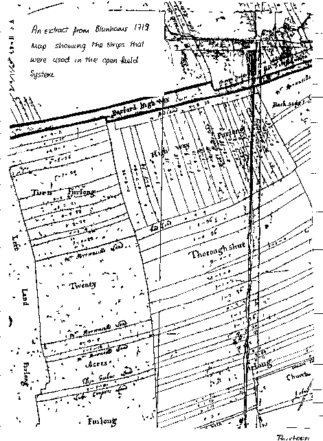
After the Roman period there seems to come a break in the organisation of fields. By Domesday Book the arable parts of England were covered with immensely complex systems of cultivation strips which were to last until the Parliamentary Enclosures.
Open field system – alias Strip Cultivation – had seven cardinal features:
- The arable of a township was divided into a multitude of strips. The strip of each farmer being distributed either regularly or at random around the township.
- The strips were aggregated into furlongs and these into fields. The same crop was grown by all the farmers on each furlong. Each field was left fallow, ploughed but not sown, every second, third or fourth year.
- The animals of the participants, were turned loose to graze the stubble and weeds of all the strips in common after every harvest and also in the fallow year. (This economised on pasture and conserved fertility).
- The farmers shared some of the labours of cultivating one another’s strips.
- Hedges were few and did not form enclosed circuits.
- Strips were ploughed in such a way as to form ridge and furrow.
- Regular meetings were held at which the participants agreed on cultivation practices and regulations and fined dissidents.
What remained open field in England was largely abolished by a series of Enclosure Acts, parish by parish mainly between 1720 and 1840.
The Enclosure Act came into Blunham in 1799. When the Blunham Enclosure was first considered, it was agreed that it should be used to extinguish the payment of tithe by giving the parson either land in lieu, or, as sometimes happened, on an annual rent charge – that is an annual payment of money charged on certain estates in the parish which sum was judged to be equivalent to the income from tithe.
Oliver Rockham19xx – The History Of The Countryside
After enclosure Blunham’s land was split up into separate fields. Everyone owned a small amount of land which was scattered throughout the parish. The largest amount of land belonged to Godfrey Thornton, and a substantial amount belonged to the Rector.
Everybody had to pay a tithe to the landlord for using the land and this varied with the amount of land that they now farmed.
The roads in the parish also changed at this stage. Due to the necessity for more privacy at Blunham House the road which had run past it (connecting Blunham with South Mills was ‘removed’. Another road which was ‘removed’ was the one which had separated the former North Field from the Middle Field.
Chalton also had some changes with access. The road which had connected it with Great Barford Bridge had become a private road – presumably for those who held power to use.
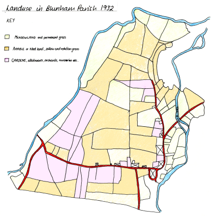
In 1932 Blunham parish had three major land uses. These were meadow land / permanent grass, arable and gardens / allotments. The arable land was the most plentiful followed by the meadow land. Meadow land was concentrated down by the river and the gardens and allotments were along the roads near the houses.
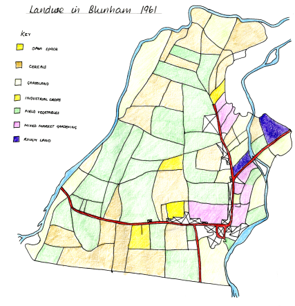
In 1961 we find that several other uses have crept into the area. For example Industrial crops, and field vegetables. The industrial crops seem to have replaced the allotments, and the field vegetables had replaced the arable land.
We can also see that field sizes have changed. They had grown larger by 1961, but many of the old field patterns still remain.
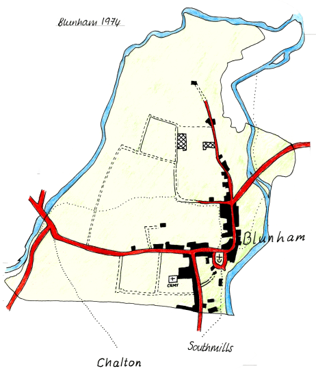
Moggerhanger, Chalton and South Mills have formed a parish of their own: Moggerhanger Parish, therefore the parish of Blunham had decreased by half its size.
The village itself has grown in size, houses have been built alongside the roads, stretching the village up and out to the west.
The road to Chalton which became a private road around 1799 has now changed to a footpath, both this and the footpaths to South Mills and the one that separated the former North Field from the Middle Field were inaccessible, a resident of Blunham told us that the local farmers had ploughed the fields which made the path very difficult to follow.
Over the years Blunham Parish has seen many changes. Its fields have been enclosed, made larger and changed in use over the centuries and now some fields are even being left redundant.
The roads through the parish have not changed significantly over the years - although three roads which were present in 1534 have now obtained footpath status. These footpaths, although they are still there, cannot easily be used as they are often ploughed up by the local farmers.
Blunham, itself, has grown in size. But it has not expanded compactly, it has expanded along its roads. Moggerhanger, Chalton, and South Mills are now of no importance as they ceased to be a part of Blunham Parish in the latter part of the 19 th Century.
Why these changes have occurred is not always clear. Roads which have disappeared or that have become footpaths changed because of Enclosure. For example Whistling Way became a footpath because the land upon which it was found was enclosed in 1799 and thus it became a field(s).
South Mills Road was removed because the owner of Blunham House wanted more privacy.
Fields have obviously changed size. This is often due to better farming practices and increased mechanisation, which made smaller fields less easy to work. Thus they became larger.
Government legislation has affected the field uses - as what the Government wanted the farmers to grow has changed and grown.
The Dedication:
St Edmund, King and Martyr, was King of the East Angles who were defeated by the Danes at Thetford in 869. He was later captured and, on refusing the share his Kingdom with the Danes because they were pagan, he was shot to death with arrows. His death in defence of his Kingdom and his faith made Edmund the object of popular veneration and the Great Abbey was founded around his shrine. By the time of Domesday St Edmunds Abbey had become the biggest landowner in Blunham and it is not surprising that the village church should be dedicated to the Abbey’s Patron Saint.Nevertheless, within living memory, the Church has always been known as St James.
The Church Building:
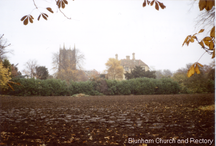
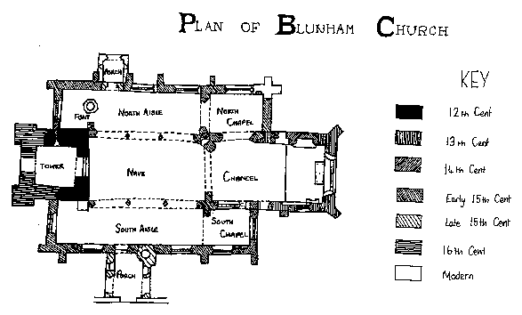
The Church building dates from the 14th Century with the exception of the tower. Its present appearance, however, dates mainly from 1862 when major restoration was carried out.
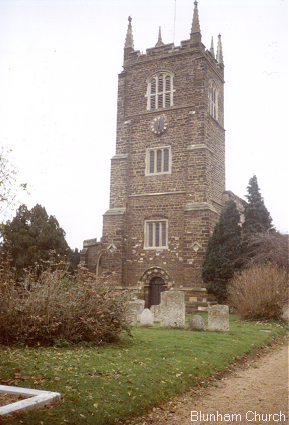
The Tower:
The tower is the oldest part of the Church. The internal and external arches are both Norman, dating perhaps from the 12 th Century. There are also two Norman windows which are visible only from the inside of the tower on the ground floor.The Churchyard:
The churchyard was closed for burials after 30th June 1904. This caused the opening of the Cemetery which lies to the west of Station Road.
Blunham and the Grey Family:
The advowson or right to present a clergyman to the living of Blunham accompanied the lordship of the manor of Blunham, from the Norman Conquest until the twentieth century. Originally the manor belonged to the Hastings family whose arms can be seen on the shield of the Duke of Kent on the west wall of the nave. When that line dies out in 1389 the manor passed to a cousin belonging to the family of Grey of Ruthyn.After the seventh Earl Coper died the Wrest Estates were sold and Blunhams connection with the Grey family and its descendants came to an end: except that in about 1950 Lady Lucas gave the parish Church a refectory table which now forms the high alter.
The Manor house had fallen down a long time ago. As far as we can tell, the Old Manor House probably stood on the Island, now the Spinney in the Rectory Garden, which we once find described in a deed as ‘the island site of the manor’.
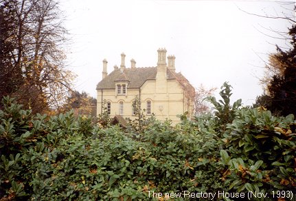
The Rectory House was the most imposing building, and its foundations must be somewhere under the present, modern house. The Greys lived in the handsome Rectory House which had been built or much repaired by the Greys for their own use.
There was a large barn of 10 bays, a smaller one of five bays called the Wheat House, a gardener’s house, a malt house, with a kiln going with it, to process the barley grown in the parish, a dove house, a stable, a garden and orchard and two fishponds. It wasn’t’ until Timothy Archer became the Rector in 1631 that the Rectory House itself returned to its proper use.
From the Publication: ‘The Parish Church of St Edumnds’
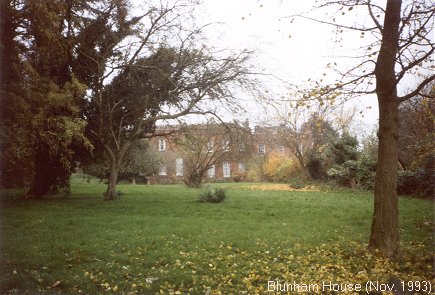
Blunham House:
Blunham House, ‘the big house’, would continue to be occupied by gentry, the Bronsalls, the Campbells, and the Paynes, into the twentieth century, but the great land-owner lived 15 miles away: too near to be called an ‘absentee landlord’: too far to leave any personal mark on the village.

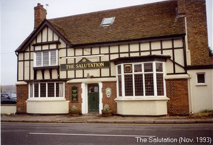
The Salutation:
There have been many pubs in Blunham over the years, but the oldest remaining pub is the Salutation. It was built in 1646 when it was named the ‘Ragged Staff’. It then became the ‘Old Salutation’ and now the name is abbreviated to the ‘Salutation’.
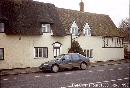
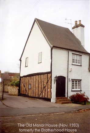
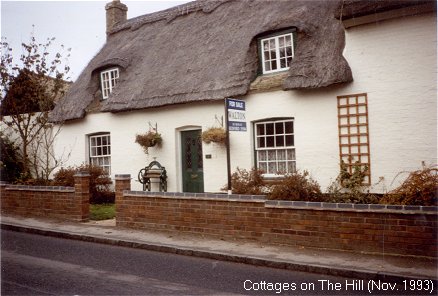
Some of the oldest cottages we found still standing, where the Hill merges with the High Street.
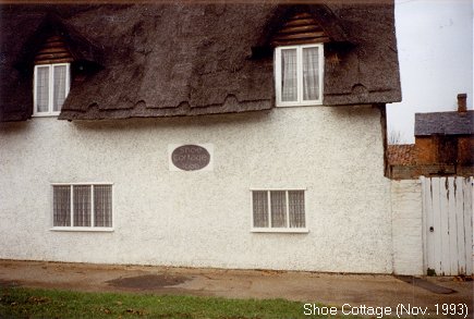
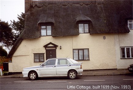
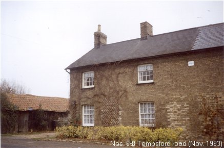
Reasonably 'new' houses situated at the North of Blunham on the road leading to Tempsford.
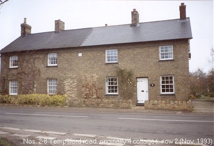
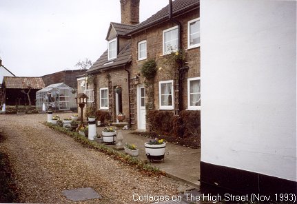
Cottages off the High Street at Brickhill Farm
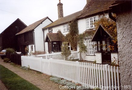
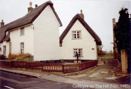
Cottages on The Hill
Research: Philippa Goodyear
Teleri Rees
Composition of Written Work: Philippa Goodyear
Teleri Rees
Map Drawing: Philippa Goodyear
Photography: Philippa Goodyear (November 1993)