1. Introduction
Once upon a time there was a Navigator. It was 1941 and his job was to drop bombs on German towns. On about 40% of his sorties, generally on moonlight nights, he was able to see the target and then usually managed to hit it with a fair degree of accuracy and a corresponding degree of discomfort for the Hun. On the other 60% of occasions, he would be flown through and over cloud and bad visibility. On arrival where the target ought to be, there were various alternatives. It it were a German target and there was a respectable cone of searchlights coming up through broken cloud and haze, he would stooge over and drop his bombs in the middle of the flak, hoping that there would be something,
in the way. If there were just a few searchlights coming through a hole in the cloud, he would probably have a crack at them by way of retaliation for being dazzled. If it were a target in occupied country it was even more unsatisfactory; once he dropped his bombs in the sea on the way back; once
he took them back to base. Coming down through the cloud never did any good - it was always very murky below and the height had to be regained on the return journey to provide some measure of security from the defended, areas over which one shouldn't pass but always did. It was all very distressing.
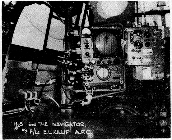
This illustration shows the Navigators position in a Lancaster fitted with H2S.
Map-reading to inland targets was usually impracticable, except on very clear nights with bright moonlight, and navigation was largely a matter of more or less intelligent "guesstimation". The Navigator obtained from the hardworking wireless operator as many loop bearings as possible from the two or three German VT beacons whose position and characteristics were given at briefing. According to the position of the beacons these bearings would give same indication of track or groundspeed; it was rarely possible to obtain anything like a "fix". Sometimes the bearings would show such wild variations that they had to be completely rejected) and the Navigator would then rely on D.R. navigation alone and hope that something recognisable would appear through a break in the clouds. He had had no practical instruction in astro-navigation; very few people had. The aircraft had no auto-controls, essential for good astro work. He took a few sights, particularly on long sea crossings, and on one memorable occasion obtained a fix, but these were taken largely for academic interest and he had not sufficient confidence to use them in the proper manner. Anyway, it was an awful bind clambering back over the main spar to the astrodome, when cluttered up with flying kit festooned with intercom-wires and oxygen tubes.
The Navigator found that he always had the least idea of his whereabouts on the homeward journey. Evasive action in the target area was one of the main factors, often resulting in the pilot getting on course when already many miles off track. The Navigator would forget to turn on his oxygen when back in his seat after dropping the bombs and would suddenly realise that he left the target some ten minutes ago without even noting the time. The pilot would remember that the Ruhr lay to starboard of the track and would subconsciously bias any evasive action to port. Now that the primary object of the flight had been fulfilled with the dropping of the bombs, a natural reaction set in, resulting in a general drop in efficiency. The Navigator would be given some loop bearings which tended to show a position some forty miles south of track, and would at first scoff at them, later becoming doubtful. But doubt was normal and certainty rare. His position errors became smaller when approaching the enemy coast, when the W/T beacons in East Anglia gave the first real indications of track errors. The flak batteries at Ostend and Dunkirk were unpleasantly accurate (they had much practice), but they at least gave him a time for "crossing enemy coast out". From here he could generally contrive to arrive within five or ten miles of base, and, if the night were clear, sighting the home beacon finished the job. In poor weather it was often necessary to call up by W/T and ask for a Q.D.M.; as some twenty other aircraft were probably calling up at the same time this was sometimes a little chaotic.
This, then, was the situation three years ago. The aircrews did their best under the circumstances, but their spirits inevitably dropped as trip after trip went by without any opportunity of hitting the Hun.
Gee came along as the greatest single stride forward ever made in air navigation. It still is the most comprehensive and completely satisfactory system. The navigational problem was immediately eased, and the aircraft would be "homed" to base with great accuracy and without overcrowding the D/F Stations. Its accuracy as a blind bombsight left much to be desired, but at least it was better than the haphazard field ploughing which undoubtedly took place on many previous occasions. It was limited in range, coverage inland not normally extending far beyond the Ruhr, but provided a solid foundation on which to base navigation to the more distant targets. Eventually the enemy brought his jamming stations into play and Gee facilities on the Continent were lost. This hindered operations for a time, though the more philosophical members of the navigators' union realised that they still had accurate fixing facilities, as far as the-enemy coast, and consequently could expect far smaller errors in their D.R. than was the case in 1941.
About this time H2S made its appearance. The original conception was a device to enable the operator to bomb a built-up area when placed within 15 miles by some other means. It was quickly appreciated, however, that here was a device with which, using care and imagination, a navigator could find his way around Europe independently of ground organisations and limitations of range. The navigational aspect now became very important due to the lack of other aids on the Continent, and considerable time was spent in investigating this problem and in training navigators in what were thought to be the best methods. What these methods were and how they are applied today will now be discussed.
2. Navigation
It was soon realised that straightforward map-reading by H2S was quite out of the question. The picture was not easy to interpret, particularly in industrial areas, and it was decided that fixes by bearing and distance should only be obtained from really large towns or from well isolated smaller towns. The basis should be good D.R. navigation, the navigator working out an E.T.A. for a position where the next large town will be within range. Thus in Figure 38 an aircraft is assumed to be flying from A to B. The navigator will work out an E.T.A. for the position B in the usual way, but will also calculate the E.T.A. for position C. He will ignore the smaller towns en route as they may be misleading and on E.T.A. will search the PPI for a large town 15 miles on the port bow. The time taken from A to C will not be more than 15 minutes, and unless something very unusual happens the aircraft will certainly be within 10 miles of C. There is only one large town in the area and if he locates a built-up area at 10 miles and almost straight ahead, he is justified in assuming that this is the town and that the wind used is incorrect. As an additional check it might be possible to identify the small town south of C by its position relative to the large town. Having made the identification it is a simple matter to take a range and bearing, thus obtaining a first-class fix, on the basis of which the D.R. can be corrected and an E.T.A. worked out for the next large town.
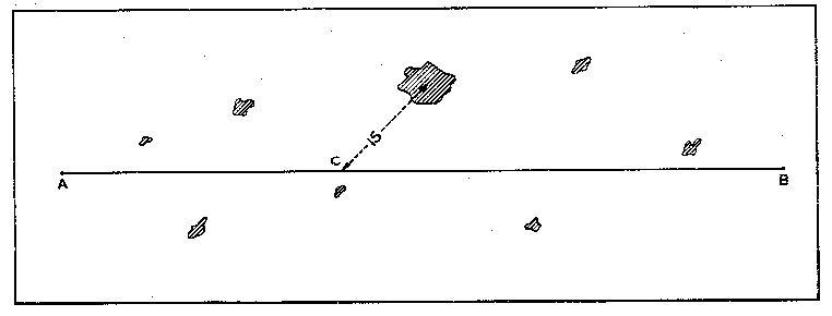
Figure 38.
The difficulty which immediately arose was this; would the navigator be able to cope with both the D.R. navigation and the H2S interpretation? Apart from the exceptionally capable few, this seemed impossible, and the bomb-aimer (in PFF often a qualified navigator) was brought in to make a navigational team of two. These two sat side by side, to ensure good co-operation. The navigator would work on the system outlined above, and notify the set operator when it became necessary to search for the next landmark. The latter would meanwhile be watching the PPI, with a map in his hand, endeavouring to identify landmarks independently. If at any time a particularly definite landmark was noticed, he would inform the navigator and take a fix.
Basically, the present-day system is much the same. The main improvement has been effected in modifying the task of the set operator, reducing the possibility of incorrect identification. He is provided with a board on which is affixed a section of the standard plotting chart covering the route. The required track is drawn in, as shown in Figure 39, which is an extract from such a chart.
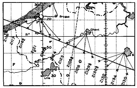
Figure 39.
On reaching the enemy coast, there will undoubtedly be some town within range of the H2S, and experience has shown that fixing errors on such towns are few and far between. Failing a town, some prominent feature of the coastline can be used. The operator takes many fixes by range and bearing from this town or landmark, and plots them on his chart. Fixes are taken until the town is out of range, when it should be possible to identify another town and repeat the process.
These fixes are taken at intervals of two or three minutes and form a continuous record of the track followed, which
should be almost a straight line. If, on choosing another
town, the fix is plotted some way out of line, there is reason to suspect an identification error, and closer inspection will usually reveal it. The time is written against each fix, and the navigator is thus provided with much up to the minute information, which he can use at his convenience. A good H2S operator will produce a chart which proves that hardly two minutes of the flight could have passed without his being able to state the position of the aircraft within a mile.
That is the general background to navigation by H2S. The fitting of the Air Position Indicator enabled the navigator to obtain a more accurate D.R. position, and a fair proportion of crews do find their way about with considerable success. Statistics show, however, that the number of aircraft which wander more than 10 miles off track is still uncomfortably large. Some of the factors affecting this, in probable order of magnitude, are as follows:-
These points are now dealt with in a little more detail.
(1) Evasive action on the route
The introduction of roll stabilisation should assist considerably, though there will still be some pilots who do such unnecessarily violent evasive action that navigation will inevitably be upset. The limits of
30° for which the stabilising platform was designed should be sufficient.
(2) Ability of the navigational team
It is unlikely that more extended training could be tolerated in view of operational requirements, and even open to doubt whether more training would achieve better results. The good operators will cope with very inferior equipment, the bad ones will probably still get lost with a perfect H2S system. Those who are at present drifting more than 10 miles off track must be considered as average, and the equipment improved until it is sufficiently straightforward for them to interpret correctly.
(3) Maximum range
H2S was, and is, officially a blind bombing aid. Operational heights have increased with improved aircraft and more opposition, and the original scanners did not give coverage inside four miles when used at 20,000 ft. In the efforts to improve bombing results, by providing a better minimum range, the aerial gain suffered, with the result that maximum ranges today, though more consistent, are little better than in the first production models. It is obvious that the average operator would be less liable to err with a workable range of 40 miles than with the 25-30 miles normally possible, but it is thought that the policy of retaining a reasonable maximum range while concentrating on bombing facilities was correct. The situation will undoubtedly be eased when the scanner with adjustable tilt becomes available.
(4) General equipment performance
The chief point here, assuming the power output to be satisfactory, is that of contrast between town and countryside echoes. This varies from set to set; with some a town stands out well above the other signals, and navigation becomes quite simple; with others a practised
eye is needed to discern a town at all. It has not been possible to devote much research to this problem due to the lack of skilled manpower and the urgent nature of other requirements, but is is nevertheless a very important point, and also affects the bombing problem.
3. Bombing
The range scale on the H2S Switch Unit has a series of red lines printed across it. Each line is for use with a particular groundspeed. By setting a pointer against the line corresponding to the groundspeed in use, the range marker is placed at a range equal to the forward travel of a bomb at that groundspeed. Thus, heading towards a particular target the bomb release button is pressed when the target echo crosses the range marker. However, targets were often indistinct at bomb release point, so a corresponding series of dotted lines were marked on the range scale. By setting the pointer to these lines, the range marker is placed at a range corresponding to the forward travel of the bomb plus 30 seconds, at the particular groundspeed. It is therefore necessary, when the target crosses the range marker, to start a stop-watch and wait 30 seconds before pressing the bomb release.
At 20,000 ft., the target became indistinct even at this point, and decided to use a system whereby the range marker was set at 5 nautical miles, at which range the target could usually be seen clearly. As the direction of attack and airspeed are known, the time which must elapse between the crossing of the 5 mile circle by the target and bomb release, was given to the operators at briefing. This method was, of course, subject to serious errors, as it entailed a straight run of about one minute, which was not always possible, and suffered from wind errors. It was, however, the best that could be done with the equipment at that time.
The introduction of H2S Mark III made it possible to follow the target practically to bomb release point. This was not properly appreciated at the time, and crews continued to use the "5 mile circle" technique, with the natural result that the Operational Research Section at Bomber Command found that Mark III was achieving no better results than Mark IIB, at any rate on average sized towns. This was a pity, as it has been found that Mark III is some 40-50% more accurate, mainly due to the better coverage at minimum range. But the real value of Mark III at the time of its introduction lay in the fact that it made possible the bombing of Berlin.
It will be appreciated that Berlin is a large and indefinite area, and straightforward bombing was liable to result in large errors. Mark III made it possible to identify the lakes surrounding the city, particularly those in the west, and several large open spaces, notably the Templehof aerodrome. Briefly the method of bombing was to manoeuvre the aircraft until it was on a given range and bearing from the tip of one of the lakes and drop the bombs. Calculations involving the forward throw of the bombs were all done in the navigation office before take-off. This method was workable, as many crews demonstrated, but it was obvious that under operational stress the system was not sufficiently flexible, and although great damage was caused in the city, the marker bombs were often widely scattered and the full effect of the raid was not felt. This experience is reflected in the design of H2S Mark IV, which is well suited to deal with the conditions of reference point bombing.
4. Conditions affecting Bombing Accuracy
It will be appreciated that, except in conditions of still air, an aircraft does not track over the ground in the
same direction as that in which it is heading. It will have an angle of drift, depending on the wind. With H2S Mark IIB and Mark III, it was necessary for the operator to calculate the drift and estimate the amount by which he must "aim off" in order to hit the target. Similarly he had to calculate the groundspeed and set it on the bombing scale. Mark IIC, IIIA and IV have a "Track Marker" which makes use of the drift information from the Mark XIV Bombsight and
enables the operator to aim directly at the target. This is an important addition, as statistics have shown that bombs are dropped, on the average, about half a mile downwind on operations, due largely to a somewhat natural disinclination to "aim off". Mark IV also has an automatic bombing marker, which indicates the forward travel of a bomb at any moment.
Apart from these points, the main factor affecting bombing accuracy is the uncertain nature of the picture at bomb release point. Apart from questions of scanner design, the often poor contrast between town and country mentioned earlier is of great importance here. The breaking up of towns into a rather indefinite collection of signals is always more pronounced when the contrast is poor. This "breaking up", which often confuses operators during a bombing run, raises an interesting point with regard to high definition systems. Unless the equipment performance is improved, a town in this case appears as a collection of scattered dots, and it is unlikely that any improvement in bombing accuracy would arise. There is nothing which delights the operator more than a good "solid" town standing out well from its surroundings.
5. Future Considerations
The ideal navigational instrument might well be one which presents a continuous record of ground position on counters situated on the pilot's instrument panel, thus obviating the necessity for carrying a navigator. But it is difficult to see how this could be done without involving the use of ground radar stations, which limitation immediately reduces the strategical freedom necessary in a long range bomber force. It seems obvious that some form of H2S will have to be carried. H2S Mark VII, now, under development, is a step in this direction.
Under present conditions it is essential to have coverage through 360° in azimuth. As was stated earlier, navigational errors are avoided by using landmarks well astern of the aircraft, and practically all reference point bombing is carried out with the landmark aft of the beam. It may well be, however, that the performance of future equipments will make map-reading on topographical features a simple matter, in which case the restriction of coverage to the forward 180° could be tolerated.
The Plan Position Indicator seems to be the most suitable presentation. Bombing accuracy calls for a high scanner speed of at least 60 r.p.m., with a high pulse recurrence frequency to avoid a "spoky" picture. Navigation requires a high maximum range, with consequently reduced P.R.F., and there seems little objection to the slow scanner speed and longer afterglow as used in the American equipment. Scanners will almost certainly require an adjustable tilt to cope with the conflicting claims of navigation and bombing.
Roll stabilisation is a desirable feature but should not be allowed to influence development to too great an extent, as there will always be scope for specialist squadrons who are prepared to sacrifice tactical freedom to obtain their results.
Page last updated on 15th February 2018 by Colin Hinson